
Grainberg

Though the Rock Bunting is mainly a mediterannean species, it has spread in Germany along the warm valley of the Rhine. As a franconian speciality it also occurs in small numbers in the valley of the Main just a few kilometers north of Würzburg. The best season for this highly desired species is from the end of March to May.
Target Species:
|
Breeders: Jackdaw, Nightingale, Rock Bunting, Woodlark
|
Access:
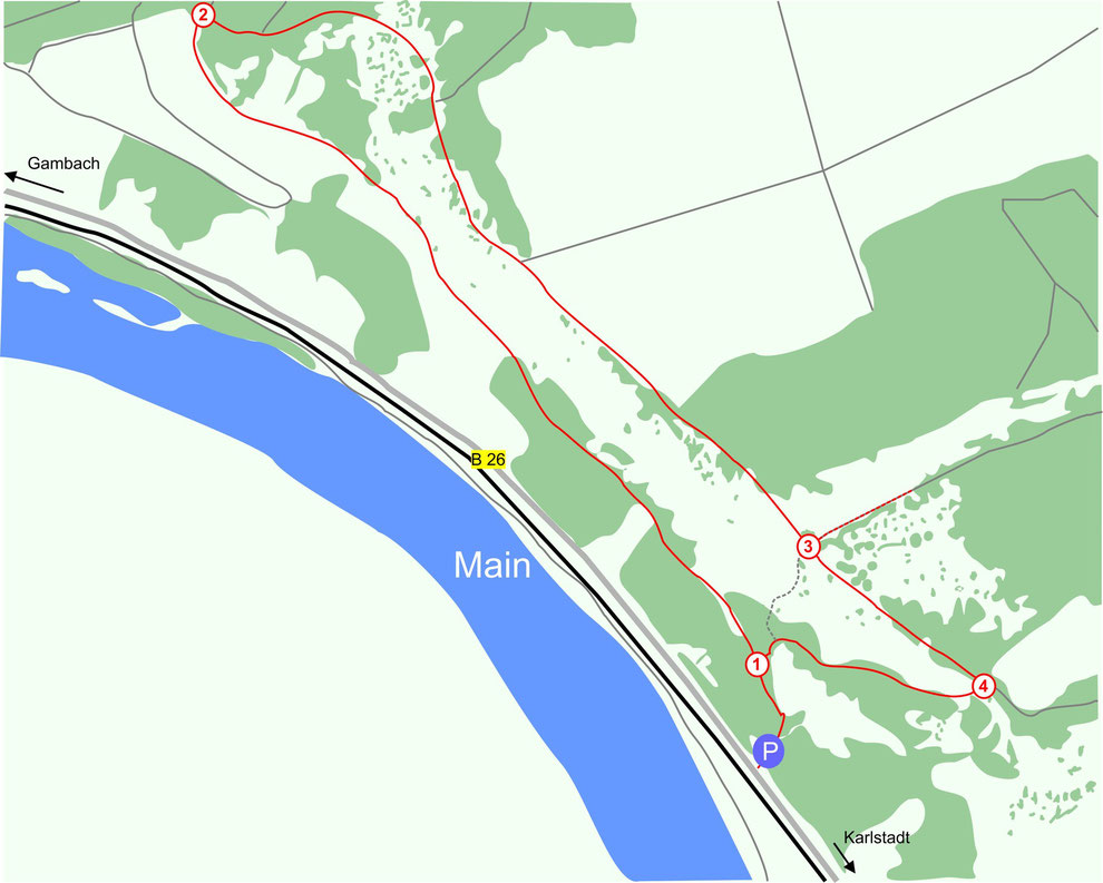
By Car: The best starting point is the car park of the „Falteshütte“ near Gambach. Coming from Würzburg follow the federal street B 27 to Karlstadt and afterwards the B 26 in the direction of Gemünden. After you've left the small town behind look out for the „Falteshütte“ on your right hand side.
By Public Transport: The next station is located in Karlstadt, from there it is only 4 kilometers to the car park. Apart from that you can also take the bus line 8060 from Karlstadt, which stops twice in Gambach. The most suitable bus stop is „Gambach-Rathaus“. Follow then the „Bachgasse“ and afterwards the „Stadtweg“. Still staying on the subsequent smaller path you'll soon reach a T-junction (2), which is another good starting point for the circuit walk.

Following the small trail uphill you'll soon reach the first T-junction (1), turn here left. The subsequent part of the circuit walk is very promising for Rock Buntings. After a while another T-junction (2) comes in sight at the edge of the forest, take here the right path in the direction of the „Edelweiß“ (the left path would lead you to Gambach). At the summit cross of the „Edelweiß“ (3) you can make a detour by turning left, the edge of the forest is the habitat of Tree Pipits, maybe you might also hear a Woodlark. Back on the main trail follow it for 200 meters and turn then right (4). On the way to the first T-junction (1) there are are once again good chances to glimpse a Rock Bunting. Pay attention in this section of the circuit walk, since it is partially steep and sandy. When it rains, it can become quite slippery.
Note that a tracking map of the area is useful for navigation, especially because there are lot of minor tracks which make it sometimes difficult to find the right path. Finally the descent from the "Edelweiß" is steep and in certain circumstances slippery.
GPS-coordinates:
(1) [49°59'25.80"N 9°45'38.38"E]
(2) [49°59'50.87"N 9°45'4.65"E]
(3) [49°59'29.79"N 9°45'42.20"E]
(4) [49°59'26.18"N 9°45'47.88"E]
P "Falteshütte" [49°59'23.19"N 9°45'38.16"E]
Sources:
Christoph Moning, Christian Wagner: Vögel beobachten in Süddeutschland, Stuttgart 2012.
http://bus-bahn-fahrplan.de/fahrplan-karlstadt/4-466488/bus-8060-karlstadt-bahnhof-gambach-rathaus (26.10.15)