
Lange Rhön

Located in the far Northwest of Franconia with hills towering almost 1000 meters above sealevel the "Rhön" borders on Hesse and Thuringia. Especially the nature
reserve "Lange Rhön" is interesting for birdwatching because of the variegated and bushy landscape with the included upland moors. For some species it is the most important breeding site in
Bavaria. Therefore a visit during breeding season is an absolute must-have.
Target Species:
|
Breeders:
Black Grouse, Black Kite (foraging), Common Raven, Common Rosefinch, Common Snipe, Corncrake, Eurasian Hobby, Goshawk, Grashopper Warbler,
Great Grey Shrike, Honey Buzzard (foraging), Meadow Pipit, Quail, Red-backed Shrike, Red Crossbill, Red Kite, Spotted Nutcracker, Stonechat, Tree Pipit, Whinchat, Woodcock, Wood
Warbler
|
|
Passage:
Black Kite, Hobby, Honey Buzzard, Northern Wheatear, Ring Ouzel
|
Access:
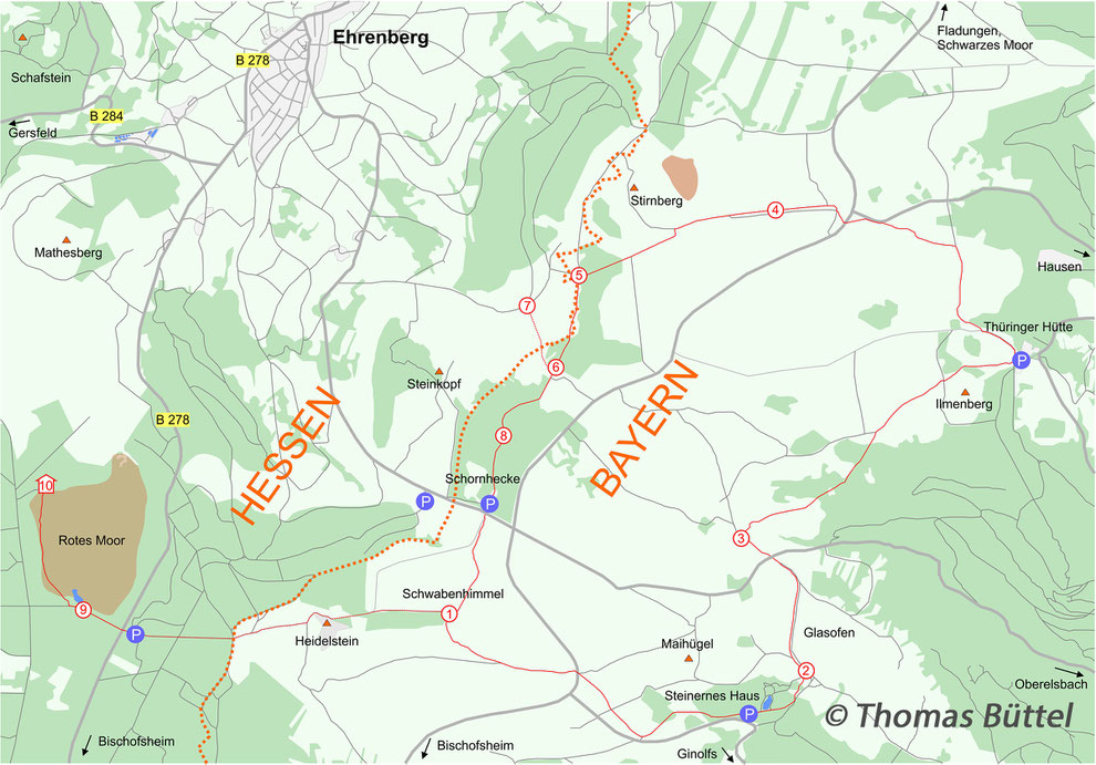
By Car: The site can be reached from the motorway A 71 in the east and from the A 7 in the south. Coming from the A 7 you have to leave the motorway at the exit "Bad Brückenau/Wildflecken". Follow then the signs towards "Bischofsheim a. d. Rhön" and leave afterwards the federal street in the direction of "Fladungen". After 12 kilometers you´ll come to a junction on a plateau, turn left and look out for the car park "Schornhecke“ on your right hand side, which is a suitable starting point.
The A 71 can be left at the exits 25 "Bad Neustadt a. d. Saale" and 24 "Mellrichstadt". In the first case you have to follow the federal street B 278 in the direction of "Bischofsheim a. d. Rhön",
keep then attention to the details described above. In the other case you‘ll come via Mellrichstadt, Ost- and Nordheim v.d. Rhön to Fladungen. From there you have to follow the signs towards the
"Schwarzes Moor", where you´ll come to a junction. Turning there left you´ll directly come after a few kilometers to the junction described above.
By Public Transport: Basically, it´s quite difficult to reach the site via public transport. The only train stations of the region are situated in Gersfeld in Hessia (distance 16 km) and in Bad Neustadt (distance 30 km). It‘s not recommendable to take the bicycle due to the steep slopes. However, with the so called „Hochrhönbus“ (line 8305) it is possible to reach the plateau from the villages around by bus, but note that this bus only stops a couple of times per day and that it is necessary to call the operators at first on working days. In any case you won‘t be at the plateau before noon.

The best strategy varies from season to season. During the breeding season the area is most profitable. Then the featured hiking tour is very recommendable, which has a length of 14,8 km and will cost you a full day. However, it is also possible to access the different spots seperately from the corresponding car parks.
Schwabenhimmel: The already mentioned hiking tour is the so called „Hochrhöntour“, an extra tour of the long-distance trail „Hochrhöner“. Therefore it is well signposted and
always marked by a red „H“ on a white background. If you start at dawn you can expect displaying Woodcocks and Common Snipes already at the parking ground (“Schornhecke“). Cross at first the
street and take then the left path instead of the paved road on the right. After nearly 300 m the trail bends to the left and leads through a bushy area to the „Schwabenhimmel“
(1). On the way Common Rosefinch, Grashopper Warbler and Whinchat are regularly seen.
Glasofen: Having reached the junction at (1) turn left in the direction of „Basaltsee“, a car park which you‘ll reach after almost 3 km. Pay there attention to signposts towards the „Thüringer Hütte“. Along the subsequent path you leave the wood and come to another interesting bushy area called the „Glasofen“ (2), where you have once again good chances for Common Rosefinches.
Elsgellen: From here the trail runs northwards to the street, which you cross. Soon after that the main hiking path makes a sharp bend to the right (3). This area (“Elsgellen“) holds Whinchat, Common Snipe and others. Afterwards you pass a woody area, where there is a chance of hearing Wood Warblers and Firecrests. Walking across another meadow the trail leads downhill to the mentioned „Thüringer Hütte“, which is not just the only restaurant on your way but also offers cottages.
Schornhecke: Take at this point the small asphalted road uphill until a wooden signpost directs you to a path on your right hand side. After 2 km you‘ll cross the street again. There you should see a meadow on your right hand side at (4), which is very attractive for migrants like the Ring Ouzel. For nearly 3 km the trail always goes uphill until you come to a bench with a wonderful outlook at (5). Turn here left and walk southwards in the direction of the car park „Schornhecke“, where you‘ve started. Immediately behind a small wood (6) you can make a small detour to the valley (7) by turning right. On the way Whinchats and Meadow Pipits reach high densities and there are yet chances to see Stonechats. Back on the main trail you just have to pass one further wood (8), where you might see Red Crossbill, Black Woodpecker and Spotted Nutcracker.
Finally, there are also some further spots on the hessian side of the area, which can easily be connected. First of all there is
another breeding area of Stonechats close by. Follow therefore the street a few hundred meters downhill (in the direction of „Ehrenberg“) to the first road on your left hand side, which is often
used as an additional car park. There you‘ll find a meadow with some rocks on it, which is just perfect for this species.
Rotes Moor: Additionally, you can pay the nature reserve „Rotes Moor“ a visit. Either you walk the 4 km on the correspondingly marked hiking path from the car park „Schornhecke“ or you drive with your car to the car park of the moor. The first signposts for cars towards the „Rotes Moor“ you‘ll already find at the junction on the plateau. Turn there right and go back to the federal street in the valley. Take afterwards the street in the direction of „Ehrenberg“, along which the mentioned car park is situated. Having reached this car park either by car or by foot, cross the street and follow the path westwards. After a few hundred meters there is a lookout (9) on your right hand side, from where you can look on a lake which normally holds only common waterfowl species, though there is a slight chance of spotting a Teal. Shortly afterwards the trail into the moor turns to the right and leads you through the birch wood to an observation tower (10), which overlooks the open area of the moor. On the way you can expect the common woodland species and a glance to the sky can be rewarded with a flying over Eurasian Hobby.
GPS-coordinates:
(1) [49°8'53.66"N 10°42'38.17"E]
(2) [49°8'43.05"N 10°42'22.00"E]
(3) [49°9'14.68"N 10°40'9.21"E]
(4) [49°7'35.05"N 10°43'10.00"E]
(5) [49°7'51.19"N 10°44'4.91"E]
(6) [50°28'42.89''N 10°1'52.74''E]
(7) [50°28'58.54''N 10°1'41.38''E]
(8) [50°28'24.81''N 10°1'31.92''E]
(9) [50°27'43.14''N 9°58'49.97''E]
(10) [50°28'16.61''N 9°58'33.47''E]
P "Schornhecke" [49°8'58.55"N 10°42'39.91"E]
P "Steinernes Haus" [49°8'56.18"N 10°40'43.26"E]
P "Thüringer Hütte" [49°7'32.51"N 10°42'59.44"E]
P "Rotes Moor" [49°7'53.06"N 10°44'10.28"E]
Sources:
http://www.thueringer-huette.com/ (04.08.17)
http://www.rhoen-grabfeld.de/Service/OePNV/Bus/Linien (04.08.17)
Kay Tschersich: Rhön – Wanderführer und Karte, Innsbruck (Kompass-Karten GmbH) 2015.